What can we expect from the La Niña phenomenon in 2024?
See how La Niña forms, its influence on the climate and its possible effects on the world agricultural market in 2024.
The El Niño phenomenon is ending its season in 2024 and La Niña is the next event that will influence the weather around the globe. The first signs of transition are already happening and the forecast is for it to become active between June and August, with a 49% chance, or between July and September, with a 69% chance.
The causes of this type of phenomenon are natural, but their effects are increasingly intense. That’s why the commodities market needs to remain vigilant in order to predict and deal with potential risks to agricultural production. In this article, you’ll find out how La Niña is formed, its prospects for 2024 and its influence on different crops and regions of the world.
Check out the content and have a good read!
How do the La Niña and El Niño weather phenomena work?
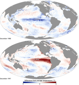
El Niño and La Niña are opposing weather patterns that disrupt the natural conditions of the Pacific Ocean. While the former increases water temperatures along the equatorial line, the latter acts in reverse, cooling the same region. Both can cause severe droughts on one side of the planet while the other suffers from heavy rainfall.
Maps of Pacific Ocean temperatures during the phenomena:

Source: NOAA
According to the National Oceanic and Atmospheric Administration (NOAA), the two phenomena usually last between 9 and 12 months, but can also last for years. La Niña is not as frequent as its opposite, but it is just as powerful. With strong winds, it pushes warm waters towards Asia, intensifying the resurgence of cold water on the west coast of the Americas.
Read also:
- What is the situation with the 24/25 wheat harvest in Brazil and Argentina?
Among the main effects of La Niña is its influence on global temperatures and the climate of different regions of the planet at the same time. It can also lead to a more severe hurricane season in the Atlantic Ocean.
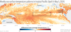
Weekly sea surface temperature patterns in the tropical Pacific (April 8 – May 5, 2024)

Source: Climate.gov
Although irregular, weather phenomena such as La Niña can be predicted and measured. The Ocean Niño Index (ONI) is the most widely used measure and is based on the average sea surface temperature of a certain region of the Pacific, marked in the image above. By combining this data with wind strength and other variables, it is possible to understand weather conditions and their prospects for the near future.
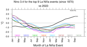
It is also possible to predict the effects of La Niña by looking at its historical influence on ocean temperatures. According to the graph below published by NOAA, the meteorological phenomena of the last century follow a similar line, with slight and regular changes, but usually with a cooling peak between the months of September and March.

Source: NOAA
The global influence of La Niña in 2024
Forecasts for La Niña have been officially recorded since 1950 and are increasingly accurate. On June 3, 2024, NOAA published the latest updates on the phenomenon, as well as a complete 70-year history.
At Hedgepoint, the influence of La Niña is also monitored periodically. This has made it possible to understand the event and predict its effects on various regions and specific crops.
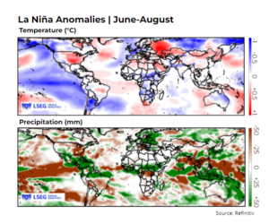
For 2024, the indices indicate that La Niña will last until at least the beginning of 2025. Between June and August, cooler weather is expected for Central and South America and West Africa. Brazil, Uruguay and Argentina could become drier, while Central America will experience heavier rainfall, which could also intensify the region’s hurricane season. Southeast Asia may experience more intense monsoons.
Below you can see the forecast for global temperatures and rainfall in June and August under the influence of La Niña:

Depending on the agricultural harvest calendar, La Niña can also pose risks to the yield of certain products. Historically, its effects can be greater depending on its intensity and correlation within each region. Below, you can see a forecast for different commodities in 2024, constructed by Hedgepoint:
-
Coffee
La Niña affects the climate in coffee-growing regions, including Brazil, Indonesia, Vietnam, Colombia, and Guatemala. In Brazil, the weather event causes lower temperatures and increases the chances of frost in coffee-growing areas of the Southeast (as happened in 1975 and 2021). This could result in a drop in productivity and below-normal rainfall, as was the case in the 21/22 harvest when yields fell by 19%.
In Indonesia, La Niña could cause heavy rains that delay the harvest. In Vietnam, there are temperature anomalies, but no clear impact on production. In Colombia and Guatemala, heavy rains can damage crops and increase susceptibility to diseases, as well as increasing the likelihood of storms and hurricanes, such as Eta and Iota in 2020. However, La Niña cannot be directly linked to the drop in productivity in these countries.
-
Soybean/Maize/Wheat
La Niña can affect these types of crops in South America, especially in Argentina, Brazil and Uruguay. The phenomenon is associated with long periods of drought and can directly affect the quality of the crop and reduce its yield.
In Asia, India and Australia, the phenomenon intensifies the humidity and rainfall. In general, these conditions are productive for the harvest in these locations. For the United States, the phenomenon develops rain and electrical storms throughout the corn belt. If La Niña really begins between July and September, it could imply benefits for farmers, but on the other hand, it could create logistical problems with the descent of water in the Mississippi River.
-
Sugar
The impact of La Niña can be both positive and negative. In Brazil, the phenomenon tends to keep the winter drier, facilitating the harvest and contributing to a higher sucrose content. However, it can also lead to a greater number of fires. The extent of the dry weather caused by the phenomenon could also harm the final yield of the 24/25 harvest and even affect the development of the 25/26 harvest if it is more intense during the spring and summer in the Southern Hemisphere.
In Central America, a moderate La Niña could bring more rain to the region and benefit sugarcane development. However, in the case of a more intense event, it could delay the harvest and intensify the hurricane season. In the Northern Hemisphere, the phenomenon could bring a positive monsoon period for the development of the 24/25 harvest in India.
Reminder:
The data provided was aimed at the regions of the world that could suffer most from La Niña. The peak of the phenomenon could still change, hitting the critical time of plant development and harvest with more or less force.
Read also:
- New EU import rules: what are the impacts on agricultural production?
La Niña 2024: the importance of monitoring the phenomenon
Five decades ago, scientists Bill Quinn and Klaus Wyrtki made the first attempt to predict the oscillations of El Niño. At the time, their motivation was to understand the impact of the climate on commercial Peruvian anchovy fishing. When sea waters warmed up, the fish migrated to colder locations, reducing fishing success and, consequently, the economic power of those involved.
Since then, forecasting this type of weather event has become essential for the global economy. That’s why companies involved in agricultural commodities should always look for information and estimates that will help them take care of their crops.
At Hedgepoint, we use detailed market data and analysis so that you can follow the market and have information that can help you in your decision-making. Subscribe to our newsletter and stay informed about all the possible effects of La Niña.


